


Precinct 32, Lyon County, Kansas
About
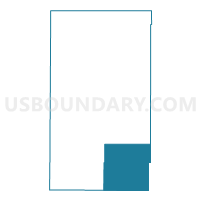
Outline

Summary
| Unique Area Identifier | 585758 |
| Name | Precinct 32 |
| County | Lyon County |
| State | Kansas |
| Area (square miles) | 99.47 |
| Land Area (square miles) | 98.93 |
| Water Area (square miles) | 0.54 |
| % of Land Area | 99.45 |
| % of Water Area | 0.55 |
| Latitude of the Internal Point | 38.25294330 |
| Longtitude of the Internal Point | -96.03601950 |
Maps


Graphs
Select a template below for downloading or customizing gragh for Precinct 32, Lyon County, Kansas


Neighbors
Neighoring Voting District (by Name) Neighboring Voting District on the Map
- Liberty Township Voting District, Coffey County, KS
- Lincoln Township Voting District, Coffey County, KS
- Madison Township Voting District, Greenwood County, KS
- Pleasant Township Voting District, Coffey County, KS
- Precinct 28, Lyon County, KS
- Precinct 30, Lyon County, KS
- Precinct 31, Lyon County, KS
- Shell Rock Township Voting District, Greenwood County, KS
Top 10 Neighboring County Subdivision (by Population) Neighboring County Subdivision on the Map
- Lincoln township, Coffey County, KS (1,281)
- Center township, Lyon County, KS (1,198)
- Madison township, Greenwood County, KS (983)
- Jackson township, Lyon County, KS (979)
- Emporia township, Lyon County, KS (907)
- Elmendaro township, Lyon County, KS (788)
- Liberty township, Coffey County, KS (555)
- Pleasant township, Coffey County, KS (254)
- Shell Rock township, Greenwood County, KS (160)
Top 10 Neighboring Place (by Population) Neighboring Place on the Map
Top 10 Neighboring Unified School District (by Population) Neighboring Unified School District on the Map
- Burlington Unified School District 244, KS (4,151)
- Southern Lyon County Unified School District 252, KS (2,893)
- Leroy-Gridley Unified School District 245, KS (1,666)
- Madison-Virgil Unified School District 386, KS (1,356)
Top 10 Neighboring State Legislative District Lower Chamber (by Population) Neighboring State Legislative District Lower Chamber on the Map
Top 10 Neighboring State Legislative District Upper Chamber (by Population) Neighboring State Legislative District Upper Chamber on the Map
Top 10 Neighboring 111th Congressional District (by Population) Neighboring 111th Congressional District on the Map
Top 10 Neighboring Census Tract (by Population) Neighboring Census Tract on the Map
- Census Tract 8, Lyon County, KS (3,525)
- Census Tract 9662, Coffey County, KS (2,947)
- Census Tract 9656, Greenwood County, KS (2,162)
Top 10 Neighboring 5-Digit ZIP Code Tabulation Area (by Population) Neighboring 5-Digit ZIP Code Tabulation Area on the Map
- 66801, KS (28,492)
- 66860, KS (1,258)
- 66865, KS (1,124)
- 66854, KS (816)
- 66852, KS (631)
- 66864, KS (456)